


Vegetation plot data for modelling, mapping and forecasting understory vegetation
Introduction
General
Climate change and elevated rates of disturbance are expected to exert profound changes in the structure and distribution of vegetation over the coming decades. These changes are anticipated to be particularly severe at high latitudes, posing many challenges to the future management and conservation of North America’s boreal forest. In Canada, a high current priority for many governmental and community groups is sustaining populations of woodland caribou (Rangifer tarandus caribou) amid these changes. Terrestrial lichen are a critical winter food source for caribou, while other understory plants are needed for summer forage. Other management challenges include: sustaining a forest products industry; providing traditional resources and economic opportunities for Indigenous communities; and tracking and predicting terrestrial carbon stocks. Understory plants play a role in all these, whether as competition for trees, food sources for humans, or carbon sinks. Effective management relies heavily upon the ability to accurately map and model lichen and other components of boreal understory vegetation. We presently lack the empirical basis to build predictive models for these taxa. This is partly due to the limited availability of ground-based, vegetation plot data. In this context, “vegetation plot data” refers to observations collected in the field of all plant species or functional types within defined areas. While these defined areas may range from quadrats, to standard radius circles, to transects, they include species, genus or functional-type specific abundance measurements (typically in the form of percent cover or stem counts) as well as associated environmental covariates (e.g. soils, moisture regime, land-cover class, overstory forest structure, etc.). Figure 1 shows an example of a quadrat from which lichen abundance measurements were taken in a transect-quadrat sampling design.
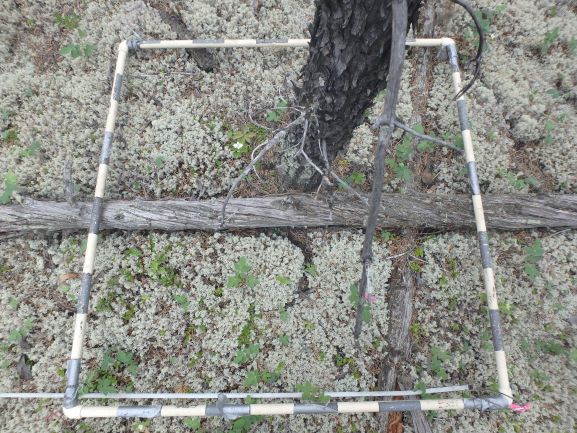
Figure 1. An example of a vegetation plot from a transect-quadrat sampling design. © Geneviève Degré-Timmons.
Many researchers have collected vegetation plot data in the North American boreal region over the years, for various purposes. To our knowledge, these disparate datasets have never been compiled and integrated. Until this is done, they can’t be used predictive modelling or mapping beyond the extent of the various individual studies. A comprehensive compilation of existing data on graminoids, forbes, shrubs, lichen, and bryophytes into a new North American database (VegPlot), will greatly enhance our ability to map and model boreal understory vegetation. To this end, we are greatly inspired by past successful data synthesis efforts such as the Boreal Avian Modelling Project (http://www.borealbirds.ca ![]() ; Barker et al. 2015), Traits Of Plants In Canada (Aubin et al. 2012), and the Canadian Biodiversity Information Facility (http://www.cbif.gc.ca
; Barker et al. 2015), Traits Of Plants In Canada (Aubin et al. 2012), and the Canadian Biodiversity Information Facility (http://www.cbif.gc.ca ![]() ) which have proven invaluable for archiving and integrating data, preventing dataset loss, and increasing data utility. In addition, these projects have connected researchers and facilitated new research collaboration that would otherwise not have been possible. We believe that a sustained effort to integrate existing boreal vegetation plot data into a widely available, open access database would similarly lead to many valuable applications and new research directions. As a step in this direction, we propose to model and map terrestrial lichen distribution and abundance over boreal North America by assembling, synthesizing and analyzing the terrestrial lichen component of vegetation plot datasets. We will assemble these data and integrate them via a common standard that is compatible with the existing Canadian National Vegetation Classification (CNVC) database (http://cnvc-cnvc.ca/
) which have proven invaluable for archiving and integrating data, preventing dataset loss, and increasing data utility. In addition, these projects have connected researchers and facilitated new research collaboration that would otherwise not have been possible. We believe that a sustained effort to integrate existing boreal vegetation plot data into a widely available, open access database would similarly lead to many valuable applications and new research directions. As a step in this direction, we propose to model and map terrestrial lichen distribution and abundance over boreal North America by assembling, synthesizing and analyzing the terrestrial lichen component of vegetation plot datasets. We will assemble these data and integrate them via a common standard that is compatible with the existing Canadian National Vegetation Classification (CNVC) database (http://cnvc-cnvc.ca/ ![]() ). We will focus our efforts on non-institutional plot data that has been collected by academic or non-governmental researchers, and on government studies not yet included in the CNVC or its provincial equivalents. This initial effort will demonstrate the value of a comprehensive plot-data compilation, and will allow us to better understand the resources in human effort and infrastructure that will be required to achieve a more complete and comprehensive database of understory vegetation.
). We will focus our efforts on non-institutional plot data that has been collected by academic or non-governmental researchers, and on government studies not yet included in the CNVC or its provincial equivalents. This initial effort will demonstrate the value of a comprehensive plot-data compilation, and will allow us to better understand the resources in human effort and infrastructure that will be required to achieve a more complete and comprehensive database of understory vegetation.
Lichen Mapping
Considerable technological progress has been made over the last decades with the generation of tools that can identify the distinct spectral signatures of terrestrial lichen. Nevertheless, direct observations of lichens below tree and shrub canopies and their associated abiotic and biotic predictor variables, while very labour-intensive, should enable more reliable predictive mapping of lichen distribution and abundance. Recent successes have demonstrated the value of compilations of such data. Greuel and Degré-Timmons et al. (accepted October 10th, 2020) modelled lichen biomass accumulation as a function of time following disturbance, forest stand type and ecoprovince, using 567 ground plots from northern Saskatchewan (Boreal Shield ecozone) and the Northwest Territories (Taiga Plains and Taiga Shield ecozones). Kennedy and colleagues used Arctic and northern boreal vegetation plot data and a variety of gridded data products, such as climate normals, to map lichen on a national scale (2020). Keim et al. (2017) modelled lichen percent cover as a function of groundwater and vegetation height covariates derived from LiDAR, using data from 438 plots in Alberta. Silva et al. (2019) modelled lichen abundance on 109 plots in Ontario as a function of ecosite, time since fire and canopy closure. Collectively, these and other such studies demonstrate the value of using vegetation plot data, remote sensing, and ecological knowledge to predict lichen distribution and abundance in boreal forest. On these bases, we conclude that a national or pan-biome analysis is possible.
Research Goals
This project has its origins in a Canadian Institute for Ecology and Evolution working group, focused on forecasting boreal vegetation dynamics including understory plants, state changes, and biome shifts. Following the meeting of this group in June 2018, an initial call for data contributions was made in the fall of 2019. The Project Leads have since hosted two in a planned series of webinars with data contributors, initially to reach consensus on project direction. From these, we have established three primary research goals:
- Mapping the present distribution and abundance of terrestrial lichen;
- Studying competition between lichen and other functional groups, and understory community composition in the context of climate change, and;
- Identifying links between lichen abundance and caribou habitat, including post-disturbance recovery.
An initial series of papers will report the findings. All data contributors will have the opportunity to participate as authors on these papers.
The comprehensive understory vegetation data contained in the database being assembled will support the future analysis, modelling and predictive mapping of taxa/functional groups other than terrestrial lichen. We hope this will lead to a deeper understanding of understory vegetation dynamics in general. However, the current focus of the project is on terrestrial lichen.
Project State as of April 30 2021
Our initial call for data has secured extensive contributions from 60 different research projects containing data from over 17000 plots distributed across the North American boreal region (Figure 2) as of April 30, 2021. The content of each dataset has been summarized, and documented in a single metadata file. This gives us the foundation for a comprehensive North American dataset. We are now actively standardizing and integrating the contributed data into the VegPlot database, guided by the structure of the PlotON database being developed by Wester et al. (in preparation) for Environment Climate Change Canada and the Ontario Ministry of Natural Resources and Forestry, Landscape Science and Technology Division and Science and Research Branch.
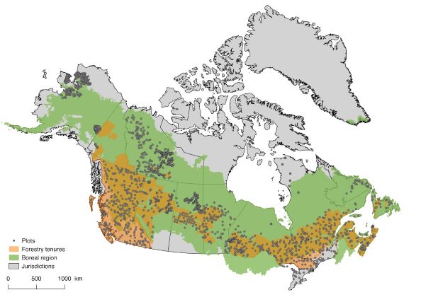
Figure 2a. Distribution of vegetation plot data assembled as of September 3, 2020 (11000 plots) across jurisdictions, in relation to tenured forest lands and forested areas. For the purposes of this initiative and for the duration of this page, the “boreal region” includes the boreal and hemi-boreal regions of Brandt (2009).
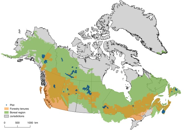
Figure 2b. Distribution of vegetation plot data assembled from the 12 representative datasets as of April 30, 2021 (4462 plots) across jurisdictions, in relation to tenured forest lands and forested areas.
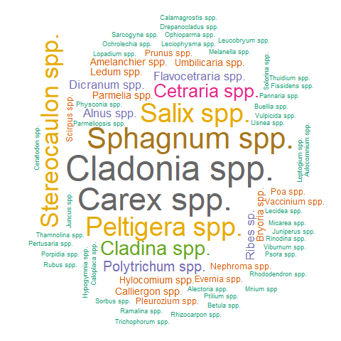
The VegPlot database initiative breaks new ground in its method of addressing and maintaining various levels of taxonomic specificity for vegetation growth forms that are challenging to identify for non-experts. Such growth forms include lichens, mosses, and shrubs. Below is a word cloud created with data extracted as of November 2020 which identifies the most common levels of taxonomic specificity for these growth forms. This image additionally demonstrates the most commonly-used names for these three vegetation groups, with larger words being more common in our datasets than smaller words.
The following figures represent summaries of the types of data we have acquired to-date. Please note that these will change as we gain access to more data on certain plant growth forms.
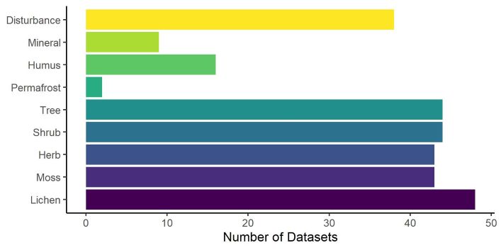
Figure 3. Number of datasets acquired as of April 2021.
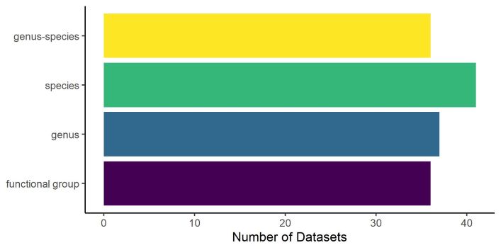
Figure 4. Number of datasets acquired as of April 2021 in which lichen was identified to various levels of taxonomic specificity.
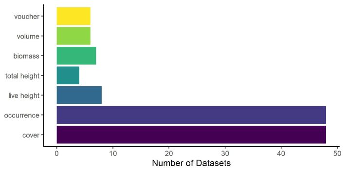
Figure 5. Type of data available for lichen analyses, current as of April 2021.
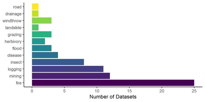
Figure 6. Type of disturbance data available for analyses. Data current as of April 2021.
Call for Data
If you are the custodian of geo-referenced vegetation plot data from boreal and hemiboreal North America ![]() (Brandt, 2009) where terrestrial lichen were measured systematically, we hope you will consider collaborating with us. We would require a copy of your plot data (including lichen and non-lichen functional groups) and associated metadata. The lichen component of your data would be used to develop boreal-wide predictive models of terrestrial lichen species distribution and abundance. Other taxa and model applications will follow. The immediate outcome of this work would be one or more manuscripts presenting the lichen model(s), and a supporting data paper. We expect that all data contributors will participate as authors. We would also study the non-lichen component of your data, to prepare for and scope the next stage of analyses of other understory taxa. Rest assured, no contributed data will be published or used without the express consent of the data owner or custodian. Data contributors will retain ownership of their data. For additional information, please refer to our official Data Request
(Brandt, 2009) where terrestrial lichen were measured systematically, we hope you will consider collaborating with us. We would require a copy of your plot data (including lichen and non-lichen functional groups) and associated metadata. The lichen component of your data would be used to develop boreal-wide predictive models of terrestrial lichen species distribution and abundance. Other taxa and model applications will follow. The immediate outcome of this work would be one or more manuscripts presenting the lichen model(s), and a supporting data paper. We expect that all data contributors will participate as authors. We would also study the non-lichen component of your data, to prepare for and scope the next stage of analyses of other understory taxa. Rest assured, no contributed data will be published or used without the express consent of the data owner or custodian. Data contributors will retain ownership of their data. For additional information, please refer to our official Data Request ![]() form. If you are interested in participating, please contact Steve Cumming (stevec@sbf.ulaval.ca) and indicate your interest. Following this, we will provide you with additional information as needed, including the database template and a link to the data use and sharing form. We are accepting new data contributions for use in the lichen modeling and mapping study until October 2021; contributions for later use are welcome at any time.
form. If you are interested in participating, please contact Steve Cumming (stevec@sbf.ulaval.ca) and indicate your interest. Following this, we will provide you with additional information as needed, including the database template and a link to the data use and sharing form. We are accepting new data contributions for use in the lichen modeling and mapping study until October 2021; contributions for later use are welcome at any time.
Project Leaders
- Steve Cumming
 (Université Laval)
- Jennifer Baltzer (Wilfrid Laurier University)
- Josie Hughes (Environment and Climate Change Canada)
- Stephen Mayor (Ontario Forest Research Institute)
- Alison Munson (Université Laval)
Data contributors
This list contains individuals or organizations who have agreed to provide us with their data as of April 30, 2021. As we receive more data, this list of contributors will grow.
Researchers
- Isabelle Aubin (NRCan) and Laura Boisvert-Marsh (NRCan)
- Dominique Arsenault (UQAR)
- Yves Bergeron (UQAT/UQAM)
- Robert Cameron (Gov. NS)
- Catherine Chagnon (ULaval) and Stéphane Boudreau (ULaval)
- Carlos Cerrejon Lozano (UQAT), Osvaldo Valeria (UQAT) and Nicole Fenton (UQAT)
- Isabella Croft Richmond (MUN) and Yolanda Wiersma (MUN)
- Anna Dabros (NRCAN) and Jaime Pinzon (NRCan)
- Scott Davidson (UWaterloo), Tasha-Leigh Gauthier (UWaterloo) and Maria Strack (UWaterloo)
- Katherine Dearborn (WLU) and Ryan Danby (Queen’s University)
- Suzanne Carrière (Gov. NT)
- Han Chen (Lakehead University) and Samuel Bartels (UNBC)
- Laura Finnegan (FRi)
- Nadele Flynn (Gov. YK)
- Sylvie Gauthier (NRCan) and Kaysandra Waldron (NRCan)
- Sean Haughian (SMU)
- Karen Harper (SMU)
- Lorna Harris (UofA)
- Jim Herriges (BLM)
- Ashley Hillman (UA), Joseph Silva (UA) and Scott Nielsen (UA)
- Mélanie Jean (UQAT)
- Kyle Joly (NPS) and William Collins
- Chris Johnson (UNBC)
- Jill Johnstone and Ruth Greuel (USask)
- Will MacKenzie (Gov. BC)
- Erin Mallon (UGuelph)
- Ariane Massé and Steve Côté (ULaval)
- Troy McMullin (Canadian Museum of Nature)
- Michael Michaelian (NRCan)
- Celia Miller (NPS)
- Sarah Stehn (NPS) and Carl Roland (NPS)
- Peter Neitlich (NPS) and David K. Swanson (NPS)
- Nelson Thiffault (NRCan) and Martin Barette (MFFP)
- Kelsey Russell (Gov. YK)
- Kirsten Reid (MUN) and Carissa Brown (MUN)
- James Schaefer (Trent University)
- Philippe St-Martin (Lakehead University) and Azim Mallik (Lakehead University)
- Martin-Hughes St-Laurent (UQAR)
- Mélanie Jean (ULaval)
- Anne McIntosh (UA)
- Alana Westwood (Dalhousie University)
- Richard Westwood (UWinnipeg)
- Andrew Park (UWinnipeg)
- Jennifer Baltzer (WLU)
- Nicole Fenton (UQAT) and Carlos Cerrejon-Lozano (UQAT)
- Carissa Brown (MUN)
- Laura Finnegan (fRi)
- Ruth Greuel (USASK)
- Susan Will-Wolf (WISC)
- (in progress)
Institutes
- National Forest Inventory
- Alberta Biodiversity Monitoring Institute
- U.S. National Parks
- FRi
- (in progress)
References
Aubin, I., C. Messier, S. Gachet, K. Lawrence, D. McKenney, A. Arseneault, W. Bell, L. De Grandpré, B. Shipley, J.-P. Ricard, and A.D. Munson. (2012). TOPIC - Traits of Plants in Canada. [Internet] Natural Resources Canada, Canadian Forest Service, Sault Ste. Marie, Ontario, Canada [Dec. 3, 2020] Available from: http://www.nrcan.gc.ca/forests/research-centres/glfc/20303 ![]() .
.
Barker, N.K.S., P.C. Fontaine, S.G. Cumming, D. Stralberg, A. Westwood, E.M. Bayne, P. Sólymos, F.K.A. Schmiegelow, S.J. Song, and D.J. Rugg. (2015). Ecological monitoring through harmonizing existing data: lessons from the Boreal Avian Modelling Project. Wildlife Society Bulletin 39(3):480-487. http://dx.doi.org/10.1002/wsb.567 ![]()
Boreal Avian Modelling Project. (2020, December 3). Retrieved from http://www.borealbirds.ca ![]()
Brandt, J.P. (2009). The extent of the North American boreal zone. Environmental Reviews, 17:101-161.
Canadian Biodiversity Information Facility. (2020, December 3). Retrieved from http://www.cbif.gc.ca ![]()
Canadian National Vegetation Classification (CNVC). (2020, December 3). Retrieved from http://cnvc-cnvc.ca/ ![]()
Greuel, R.J.*, G.É. Degré-Timmons*, J.L. Baltzer, J.F. Johnstone, E.J.B. McIntire, N.J. Day, S.J. Hart, P.D. McLoughlin, F.K.A. Schmiegelow, M.R. Turetsky, A. Truchon-Savard, M.D. van Telgen and S.G. Cumming. (Accepted 10 October 2020). Predicting patterns of lichen biomass recovery following boreal wildfires. Ecosphere.*These authors contributed equally to this manuscript.
Keim, J.L., P.D. DeWitt, J.J. Fitzpatrick, and N.S. Jenni. (2017). Estimating plant abundance using inflated beta distributions: Applied learnings from a lichen-caribou ecosystem. Ecology and Evolution 7:486–493.
Kennedy, B., D. Pouliot, M. Manseau, R. Fraser, J. Duffe, J. Pasher, and W. Chen. (2020). Assessment of Landsat-based Terricolous Macrolichen Cover and Change Analysis over Caribou Ranges in Northern Canada and Alaska. Remote Sensing of Environment 240.
Silva, J.A., S.E. Neilsen, C.T. Lamb, C. Hague, and S. Boutin. (2020). Modelling lichen abundance for woodland caribou in a fire-driven boreal landscape. Forests 10(11) https://doi.org/10.3390/f10110962 ![]()
Wester, M., J.S. Hughes and S.J. Mayor. (in preparation). PlotON: Development of an integrated database of ecological plots of Ontario. Environment Climate Change Canada and Ontario Ministry of Natural Resources and Forestry, Landscape Science and Technology Division and Science and Research Branch, Ottawa and Peterborough, ON. 24 p. + appends.