


Forêt Montmorency experimental watershed (BEREV)
Over 50 years of hydrological and meteorological datas to highlight
Approximately 80 km north Quebec City extends a remarkable forest. Considered for its hilly landscapes, which make the joy of outdoor enthusiasts, the Forêt Montmorency remains first and foremost a teaching and research territory in forestry, managed by Université Laval. Created in 1964, this balsam fir with birch zone had an area of 66 km2 (6600 hectares) until its enlargement in 2012. Its surface extends now over 412 km2 (41 200 hectares). Studied for more than five decades, the Forêt Montmorency is aptly titled as an open-air laboratory in forest management. The experimental watershed (Bassin Expérimental du Ruisseau des Eaux-Volées - BEREV; 47° 16’ 20’’ N, 71° 08’ 20’’ O) is located in this territory.
BEREV historic
As part of the international hydrology decade launched by the UNESCO in 1965, a federal government investment allowed new research in more than 30 watershed across Canada. It is in the wake of this interest that the BEREV was created in 1965, thanks to the efforts of, inter alia, Rénald Naud (hydrometeorology professor at Université Laval), André Lafond (forest ecology professor at UL) and Michel S. Slivitzki (hydrologist at the Quebec Ministry of Natural Resources).
The aim of this major project was to push forward hydrological sciences, which was a growing field. Specific objectives were (1) to understand hydrological processes (meteorology, debits, water quality, roles of the soil) and establish connections between them; (2) to understand forestry practices effects on water; (3) to transfer knowledge for land planning; (4) to stimulate the formation of forestry hydrologist. The selection of a small watershed (<10 km2) completely included in the Forêt Montmorency territory was judicious to ensure a long time research. The BEREV site has been created with the setting up of three meteorological stations and the construction of four weir gauges between 1965 and 1971.
From 1972, André P. Plamondon (forest hydrology professor at Université Laval) managed the development and coordination of the BEREV until his retirement in 2006. Since 2010, Sylvain Jutras (forest hydrology professor at Université Laval as well) took over the BEREV management and is totally committed to highlight and add value to the historical data of this exceptional experimental site. It is now imperative to exploit the enormous quantity of data accumulated during the five last decades.
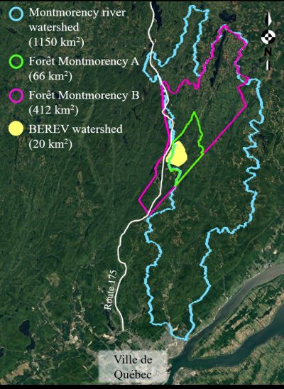
Geographical location of the Forêt Montmorency
to the north of Québec City
Geographic and climatic situation of the BEREV
According to climate normals from 1981 to 2010 (Environnement Canada, 2018):
- Annual mean temperature is 0.5°
- January is the coldest month with a mean temperature of -15.9°C
- July is the hottest month with a mean temperature of 14.6°C
- Annual precipitations are very abundant, exceeding 1500 mm
- Nearly 40% fall as snow, between November and April
- That represent over 6 m of snow each year!
- Altidude of the watershed vary between 560 m and 1000 m
A meteorological heritage of exception in the Laurentides massif
From 1965, a meteorological station named « main station » is installed in front of the Forêt Montmorency visitor reception pavillon thanks to an agreement between Université Laval and the Quebec Ministry of Natural Ressources. Two more meteorological stations were built in 1965 (station 6) and in 1967 (station 8). For over three decades, 365 days a year, a meteo observer took bi-daily meteorological data whereas data logger recorded certain data continuously. The diversity of devices and the expertise of the observer over time confers a unique quality status of the data. Since 2003, the main station was completely automated and is now under the aegis of Environment Canada.
Fun fact
BEREV stands for « Bassin Expérimental du Ruisseau des Eaux-Volées » wich translate literally by « experimental watershed of the stolen-water stream”. The name of “ruisseau des Eaux-Volées » would come from the fact that water was « stolen » from Hupé lake, situated upstream, according to a diversion made by dynamiting around 1940. Water was divert to another watershed to allow the harvested wood to float enough to the Montmorency river! Not in use anymore, the location of the canal is still visible today.
During certain periods when resources were available, there were also other meteorological stations on the territory. This is rare and now very useful to study, among others, climate change. Indeed, there were periods extending over than 20 years when 10 additional stations measured the pluviometry continuously, when 13 stations registered temperature and relative humidity and when 26 station allowed to collect weekly rainfall. Several of these stations were located on summits of the Forêt Montmorency, something rather rare before the installation of automated stations.
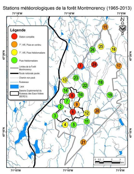
| Station name | Data collection period | Measured parameters |
| Main Station (visitor reception pavillon) | 1965-2003 (bi-daily observer) 2003-today (automated) | Temperature, precipitations, snow cover, relative humidity, sunshine duration, solar radiation, wind speed and direction, cloud cover and evaporation. |
| Station 6 (threshold 6 of BEREV) | 1965-1986 (daily observer all year long, including winter) | Temperature, precipitations, snow cover, relative humidity |
| Station 8(threshold 7A of BEREV) | 1967-1982 (daily observer all year long, including winter) | Temperature, precipitations, snow cover, relative humidity |
| Laflamme lake station | 1983-1997 (daily observer) 1999-today (automated) | Temperature, precipitations, snow cover, relative humidity |
| 10 stations | 1967-1999 | Continuous pluviometry (summer only) |
| 13 stations | 1967-1997 | Temperature and relative humidity (summer only) |
| 26 stations | 1972-1991 | Weekly rainfall (summer only) |
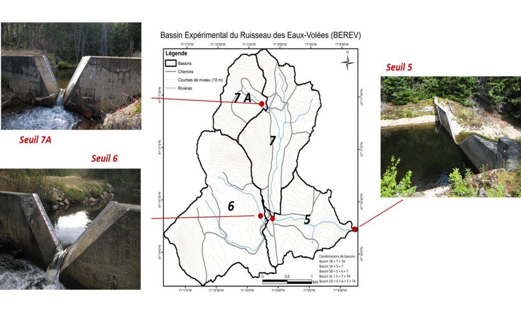
Subwatershed ocalisation and wiers gauges on the
BEREV territory at the Forêt Montmorency.
Cliquez sur l'image pour l'aggrandir
Hydrological stations to understand streams
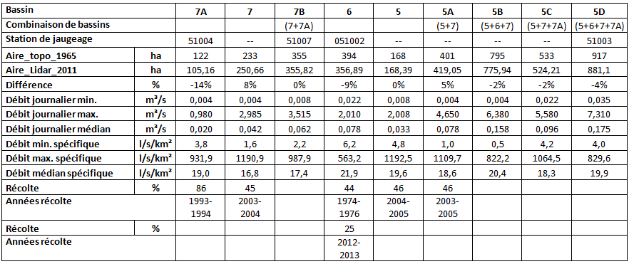
To study the hydrological behavior of the BEREV, three concreted thresholds for gauging were built between 1965 and 1967. In 1971, a threshold made of cement bags was added. These thresholds, being situated at the outlet of watersheds interlocked one in each other, allow to measure and characterize the river flow of nine sub-watershed with surface from 1,2 to 9,2 km2. The Ministry of Natural Resources was in charge of the thresholds and of the debits measure (with a bubble limnimeter and by theoretical rating curve) from their construction to 1990. Afterward,infrastructures were bequeathed to the “Faculté de Foresterie et de géomatique” of Université Laval, whereas the measuring team staid the same (from “Centre d’expertise hydrique du Québec” of the Ministry of Natural Resources). Maintenance of thresholds were made over time, most recently in 2010-2011. Concreted thresholds are characterized by a big precision and constancy in the data acquisition. The threshold made of cement bags had to be repaired a couple times including addition of concrete, which make data periodically doubtful. BEREV data are frequently used to improve hydrological knowledge in Québec, to better understand impacts of forestry on watersheds and to follow climate evolution.
BEREV hydrological stations: area, flow and harvesting between 1965 and 2013 .
An exceptionally fine knowledge of the territory and vegetation
Thanks to the efforts led by a panoply of students and professors since its creation, the Forêt Montmorency is a place having been inventoried with an accuracy and an unequalled density. Uncountable geo-spatial information sources are easily accessible under diverse digital forms, what allows to make a historic follow-up of big precision on the watershed scale. Recently, efforts of compilation and organization of historical data allow to value plentiful archival of aerial photographs thanks to their assembly in the form of digital ortho-photographs. Thanks to the technology LiDAR, is added to it two complete covers (2011 and 2016) of the territory of the Forest. Several by-products of these very high-resolution geospatial data (matrices of 1 m x 1 m) are available from now on (digital terrain model, model of height of trees cover, surface runoff, etc.).
Concrete results for a better forest management
Certain hydrological studies made on the BEREV demonstrated that a harvest of more than 50% of a watershed of 120 ha leads to a significant increase of the peak flows (Guillemette et al. 2005).
On a smaller scale (<50 ha), to harvest exactly 50% of the watershed didn’t significantly increased the peak flows (Tremblay et al. 2008) and did not make increase the concentration of anions, cations and metals over the known water quality limits (Tremblay et al. 2009).
These works support the Quebec regulation to limit the forest harvesting on sensitive watershed such as these supplying salmon rivers (Langevin et Plamondon 2004).
Studies for the progression of best forest management in Quebec
The BEREV is the only infrastructure allowing to measure directly the effects of forest harvesting on water flow and quality. These measures at watershed scale are completed by hydrometeorological process studies and plot scale studies on the Forêt Montmorency territory. Noteworthy that flow in natural environment was also studied in the ecological reserve of Laflamme lake watershed. BEREV objectives and data inspired dozens of publications, thesis and final year projects. The main studies contributing to the development of forest hydrology are listed below.
Process studies:
- Radiations and albédo (Bernier and Plamondon 1983)
- Evapotranspiration (Mathieu 2005)
- Snowmelt (Jones et al. 1986, Prévost et al. 1990)
- Hydrogeology (Rochette 1971 )
Studies at plot scale:
- Interception and transpiration (Prévost and Plamondon 1987, Icaza 2005)
- Accumulation and snowmelt (Roberge et al. 1998, Prévost et al. 1991, Talbot et al. 2006, Plamondon et al. 1984 a et Plamondon et al. 1984b.)
- Soil water (Sklash and Farvolden 1979, Barry et al. 1998)
- Erosion (Plamondon and Thomassin 1982).
Studies at watershed scale (BEREV):
- Hydrological behaviour after forest harvesting (Plamondon and Ouellet 1980, Yuxi 1997, Guillemette et al. 2005, Tremblay et al. 2008)
- Water quality (Beaudin 2002, Joffre 2004, Tremblay et al. 2009)
- Water balance (Guillemette et al. 1999)
Studies at watershed scale (Lac laflamme):
- Water balance (Martel 1983)
Value a remarkable history of data to explore new hypotheses
The BEREV infrastructures celebrated its 50th in 2015 and can be praised to have served abundantly to validate various hypotheses and to develop recommendations linked to forest management impacts on water resources in Quebec. The future of the BEREV is based obviously on the promotion of its past, but also in the pursuit of hydrological studies in forest environment. Several searches are in progress in connection with the processes of sub-captation of the solid precipitation, the interception of the precipitation in forest environment, the direct measure of the evapotranspiration and the hydrological modelling.
On the other hand, the promotion of historical data passes inevitably by an exploitation and a more efficient distribution of corrected, validated and homogenised hydrometeorological data. The construction of an online metadata base, hosted on the website of the “Centre d’Étude de la Forêt”, is a crucial step completed thanks to the support of long-time universities collaborators. This will contribute to the scientific reputation of this exceptional site and to the efficient diffusion of its archives, formerly difficultly usable.
Online unique data from five decades on small watershed in Canad
The metadata base of meteorological and hydrological data collected at the Forêt Montmorency since 1965 are now available online.
For further information and to reach archives, visit Catalog of climatic data of the Forêt Montmorency
or contact Sylvain Jutras ![]() , ing.f, Ph.D.
, ing.f, Ph.D.
Last update : 26 janvier 2018
Global Water Future
Maxime Beaudoin-Galais began in the winter 2018 a doctorate concerning the effects of the forest harvest and the changes of vegetation on the hydrological balance and the boreal flow in forest. This project is connected with Global Water Futures ![]() (GWF), a pancanadien initiative to strengthen the role of Canada as leader in hydrological sciences in cold regions. More specifically, the Université Laval contributes to this vast campaign through Boreal Water Futures
(GWF), a pancanadien initiative to strengthen the role of Canada as leader in hydrological sciences in cold regions. More specifically, the Université Laval contributes to this vast campaign through Boreal Water Futures ![]() (BWF), formed to supply tools and strategies surrounding the risks associated to the water of the ecosystems of the boreal forest.
(BWF), formed to supply tools and strategies surrounding the risks associated to the water of the ecosystems of the boreal forest.
In connection with the vision of BWF, the general objective of this project is to better understand the effects of the changes of vegetation (eg: forest harvest, insect epidemics, etc.) on the hydrological balance on the scale of a watershed in boreal forest. The study will be made by the analysis of hydrological data of the BEREV. By means of detailed informations on the operations of harvest made on the site of study and spatial analyses, it will be possible to compare the changes of vegetation with the hydrological data of the various subwatershed of the BEREV. Also, by including the BEREV within the Pan-Canadian Boreal Observation Netword ![]() (BON), the results of digital analyses and hydrological modellings can be compared with other similar sites somewhere else in Canada
(BON), the results of digital analyses and hydrological modellings can be compared with other similar sites somewhere else in Canada
EVAP project (Hydrological modelling with energy balance)
The main objective of the project is to improve the modelling of the evapotranspiration within hydrological models used in a operational way, to better estimate the impact of climate change on the hydric regime of streams.
Visit the ÉVAP ![]() project page to know more about it.
project page to know more about it.